Friday, January 28, 2022

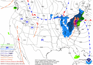
Major Winter Storm for the New York City Metro Area and Coastal New England Saturday and Sunday...Wind Gusts to 75 mph, Up to 2 Feet of Snow, Blizzard Conditions Along the Coast...

A fast moving and "bombing" area of low pressure will produce the strongest winter storm of the season for the Northeast. A bomb low pressure system is one that drops in pressure by 24 mb or more in 24 hours.  This storm may drop as much as 40 mb as it rapidly intensifies east of Long Island on Saturday. The heaviest snow will fall along the coast and eastern Long Island and into Boston. Locally as much as two feet of snow will fall in these areas. The city is expected to receive 6 to 12 inches, the Jersey Shore 12 to 18 inches and eastern Long Island 18 to 24 inches.  This storm was hinted at by the American GFS model about 10 days ago.  The storm is a fast mover and the snow will end in the NYC metro area by early Saturday evening.  Temperatures will be cold and there will be blowing and drifting of snow that will produce whiteout conditions.  Power outages are also a possibility, travel will become impossible. Blizzard Warnings are in effect for the Jersey Shore and eastern Long Island. Two feet or more of snow is forecast for Boston and Cape.  Be safe everyone.   
George Wright is a Certified Consulting Meteorologist for Wright Weather Consulting, LLC. Visit our website at WrightWeather.com. Follow George Wright on Twitter @gwweather.


Sunday, January 16, 2022

Heavy Rain and Wind for New York City Tonight and Monday Morning, High Wind Advisory in Effect

A strong storm will track northward through New Jersey on Monday. Snow fell earlier this evening in the city producing about an inch before it changed to rain.  The storm will take an inland track tonight and Monday and all areas in the NYC metro area will change to rain. A Wind Advisory and a Coastal Flood Watch are in effect. Wind gusts to 50 mph are expected along the coast. The weather will be cold and dry for the New York City area for the rest of the week.  Below normal temperatures and precipitation are forecast for the next two weeks in the Northeast.
George Wright is a Certified Consulting Meteorologist for Wright Weather Consulting, LLC. Visit our website at WrightWeather.com. Follow George Wright on Twitter @gwweather.


Wednesday, January 05, 2022

First Accumulating Snow Possible Tomorrow Night and Friday for New York City...

Low pressure is forecast to develop over the South during the day on Thursday. Moisture from the storm will race northeastward as an upper level trough moves in from the west.  The storm is forecast to move a little east of the 40/70 (lat./long.) benchmark meteorologists use in the Northeast to determine if a storm track will produce signifcant snowfall.  If the storm passes farther east of this location, less snow is expected, if it passes closer to the coast, the snow may mix with sleet or rain.  The models agree that the storm will track far enough east to produce only 1 to 3 inches with the most snow expected over eastern Long Island.  This will be the first accumulating snow of the season in New York City.  The only measurable snow so far this season was the two-tenths of an inch that fell on Christmas Eve morning.  The weather will be colder and dry after the storm moves away Friday, milder weather in the 40s is expected for the city on Sunday.   
George Wright is a Certified Consulting Meteorologist for Wright Weather Consulting, LLC. Visit our website at WrightWeather.com. Follow George Wright on Twitter @gwweather.